A six-story medical office building planned near the Piedmont Columbus Regional campus hit a snag: the initial borings suggested competent rock at 30 feet, but the contractor's probe refusal was erratic, swinging from 20 to 60 feet within a 100-foot span. The architect needed a continuous profile of the rock surface to set foundation elevations without burning through contingency funds. We mobilized a 48-channel seismograph and ran four seismic tomography lines across the site. The resulting P-wave velocity model revealed a buried paleochannel filled with soft saprolite that the discrete borings had missed entirely. In Columbus, where the geology shifts from crystalline Piedmont rock to Coastal Plain sediments right along the Fall Line, seismic tomography often becomes the deciding factor between a straightforward design and a costly redesign. We combine seismic refraction data with reflection processing when the velocity contrast is subtle, giving structural engineers a defensible site class per ASCE 7 Chapter 20.
A continuous velocity cross-section across the Columbus Fall Line can reveal the rock surface to within one foot, eliminating the guesswork that isolated borings leave behind.
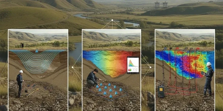
Local context
ASCE 7-22 Section 20.1 requires a site-specific shear wave velocity profile for any seismic design category D, E, or F project when the simplified site classification cannot resolve subsurface uncertainty. Columbus sits in a moderate seismic hazard region—not high enough to dominate structural design, but high enough that misclassifying a site from Class C to Class D can add hundreds of thousands of dollars in unnecessary lateral force demands. The real risk on the Columbus side of the Chattahoochee River is the irregular bedrock surface combined with saprolite layers that retain the fabric of the parent rock but carry essentially no shear strength when saturated. We have imaged zones where the velocity drops from 8,000 ft/s to below 3,000 ft/s over a distance of 40 horizontal feet, right where a developer planned a continuous strip footing. Without the tomogram, that weak zone would have remained hidden between borings until differential settlement cracked the slab. In the southern part of Muscogee County, solution cavities in the Clayton Formation limestone introduce a second hazard: a velocity inversion that reflection processing can flag when the P-wave signal bounces off the air-filled void. Missing that signature means a column load could punch through the roof of a cave that has been stable for millennia.
FAQ
How much does a seismic tomography survey cost in Columbus Georgia?
For a typical commercial site in Muscogee County, a 2D P-wave refraction tomography survey with 24 to 48 geophones and a sledgehammer source runs between US$2,800 and US$4,660, depending on the number of lines, line length, and site access conditions. Surveys that require an accelerated weight drop for deeper penetration or combined reflection processing fall at the upper end. Every proposal includes mobilization within the Columbus metro area, raw and processed SEG-2 files, and a signed report with interpreted velocity sections.
How deep can seismic refraction see in the Piedmont saprolite around Columbus?
With a 48-channel spread at 10-foot spacing and a sledgehammer source, we typically image 50 to 70 feet into weathered Piedmont rock, which is deep enough to capture the transition from saprolite to partially weathered rock to competent gneiss or schist. If the project needs to map the fresh rock surface beyond 100 feet—common for deep excavation work near the Chattahoochee River—we bring an accelerated weight drop that extends penetration by 30 to 50 percent.
Can seismic tomography detect sinkholes in the limestone south of Columbus?
Yes, with the right acquisition geometry. P-wave refraction alone can miss a clay-filled cavity because the velocity contrast is small and the feature may appear as a subtle low-velocity zone. We run a combined refraction and reflection survey in karst-prone areas: the reflection processing stacks the P-wave energy that bounces off the top of the void or the clay-limestone interface. That gives us a reflector horizon that can be mapped across the site, even when the first-arrival tomogram looks unremarkable.
What is VS30 and why does the structural engineer need it for a Columbus project?
VS30 is the average shear wave velocity in the upper 100 feet of the subsurface, and it determines the site class—A through F—that dictates the seismic design forces per ASCE 7. In Columbus, sites near the Fall Line can straddle two classes because the rock surface rises sharply over short distances. We measure VS30 with a surface wave method like MASW or ReMi, which uses a linear geophone array and either active shots or passive ambient noise to extract a dispersion curve. The result goes directly into the structural engineer's response spectrum calculation.