The Fall Line cuts right through Columbus, and that geologic boundary between the Piedmont’s hard rock and the Coastal Plain’s deep sands does strange things to how the ground shakes. Up on the north side you’ll find stiff residual soils over weathered gneiss, but drop south toward Fort Moore and the Chattahoochee River terraces and you’re suddenly in loose, saturated alluvium that can lose its strength in seconds during a major tremor. We’ve seen enough boring logs from the Midland and Bibb City areas to know that standard blow counts alone don’t tell you the full story when the water table sits barely 8 to 12 feet down in the river bottoms. For projects anywhere near the 100-year floodplain, a CPT test gives us continuous tip resistance and pore pressure data that picks up thin silt seams an SPT spoon will miss entirely, and those seams often control whether a layer drains or traps pressure during cyclic loading.
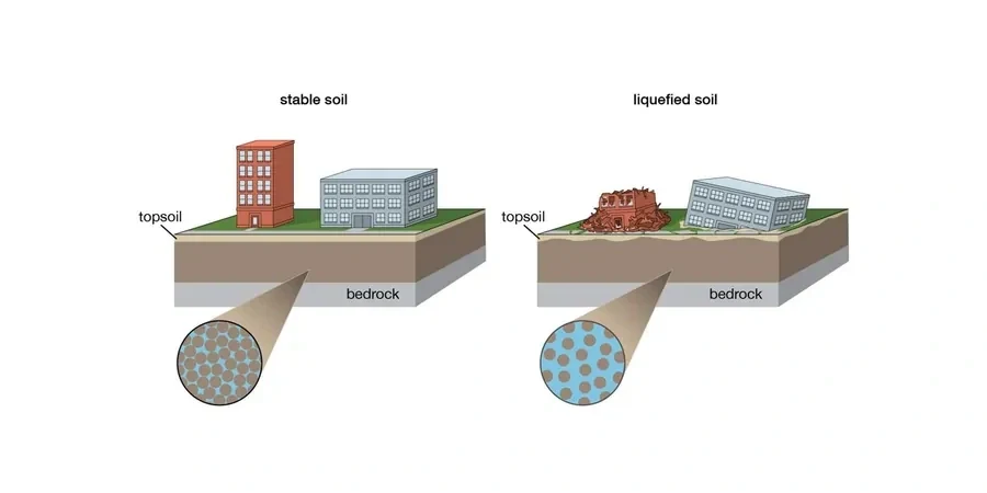
Liquefaction in Columbus isn't about total ground failure — it's about the 1 to 3 inches of differential settlement that cracks slab-on-grade floors and snaps utility lines before anyone notices the tilt.
Local context
The biggest wildcard in Columbus isn’t the seismic hazard itself — it’s the man-made fill that covers old creek beds and ravines all through the downtown corridor and the redevelopment zones along Veterans Parkway. Pre-USGS mapping from the 1970s shows dozens of unmapped drainage features that were filled with uncontrolled sandy silt during mid-century construction, and those pockets of loose, wet material sit right under slab-on-grade commercial buildings with zero ground improvement. During cyclic loading, these fills can trigger a flow failure that propagates laterally toward the nearest open cut, which in Columbus often means the Chattahoochee River bank or one of the steep tributary draws. That lateral spread displacement, even at just 4 to 6 inches, is enough to shear pile caps and pull apart grade beams. Our team cross-references historic topographic quadrangles with current LiDAR bare-earth models to flag these buried features before a single borehole gets drilled, because the standard 50-foot grid spacing on a quick-turnaround site investigation will miss a 20-foot-wide paleochannel every single time.
Reference standards
ASCE 7-22 Chapter 16 (Seismic Design Requirements, Site Class F evaluation for liquefaction), IBC 2024 Section 1803 (Geotechnical Investigations, liquefaction assessment), ASTM D1586-18 (Standard Penetration Test, N60 and N1,60 correction for liquefaction analysis), ASTM D4318-17 (Atterberg Limits, PI threshold for Chinese criteria), Youd et al. 2001 / NCEER-97 (SPT-based simplified procedure), Seed & Idriss 1971 (cyclic stress ratio framework)
FAQ
At what depth do you typically find liquefiable soils in Columbus?
Most of the problematic layers sit between 6 and 30 feet below grade in the Chattahoochee River alluvium and its tributary deposits. Below about 35 to 40 feet, the overburden pressure generally raises the cyclic resistance enough to push the factor of safety above 1.1 for the design earthquake, unless you're dealing with a very loose, clean sand with N1,60 values under 8 blows per foot. We always carry the analysis to at least 50 feet to confirm the transition to competent material.
What does a liquefaction study cost for a typical commercial site in the Columbus area?
For a standard commercial lot with two to three boreholes, full SPT-based liquefaction analysis, laboratory fines content and Atterberg testing, and a signed report with settlement estimates, the cost typically falls between US$2,460 and US$4,380. Adding CPT soundings or running a lateral spread displacement analysis pushes toward the upper end of that range. We provide a fixed-fee proposal after reviewing the site location and the structural loading assumptions.
Does ASCE 7 require a site-specific analysis or can I just assume Site Class F for liquefaction?
Under ASCE 7-22 Section 11.4.8, if the site contains soils vulnerable to liquefaction under the design earthquake, you must perform a site-specific ground motion analysis unless the structure falls into Risk Category I and the engineer can demonstrate negligible consequence. Triggering Site Class F is not the end of the process — it's the flag that says you need a quantitative assessment of settlement, bearing loss, and lateral spread before you can finalize the foundation design. We deliver the full analysis package that the structural engineer of record can cite directly in the construction documents.